


CHAPTER 1
ANCIENT EROSION, FORMATIONS*1,
AND DEPOSITION OF STRATA
ANCIENT EROSION, FORMATIONS*1,
AND DEPOSITION OF STRATA
[015] Christian authors have many times attempted to visualize and understand the nature of the earth's sedimentary cover. Just what do the rock layers (strata) which we see in road cuts and on the sides of mountains represent? How and when were they formed, and what changes have they undergone in the past? Have some of the layers been worn away and replaced by other rock layers at a later time? In the list of six statements concerning rock strata, quoted above from the book Scientific Creationism, Dr. Morris gives a hydraulic engineer's conception of what the answers to some of these questions might be. He recognizes the fact that water plays an important part in the deposition of some sediments, but neither his list nor the comments which follow it in the book take into account the many principles of deposition and rock formation which are now known as a result of careful geologic research. Many distinct processesof sediment production and accumulation, rock lithification, and erosion are now known to operate on the earth in forming new parts of the layered sedimentary cover. (It is incorrect to suppose that rock formation processes are no longer operative upon the earth.) A knowledge of these processes reveals to us, as we study their marks in the strata, an entirely different picture from that of a mere amassing of great thicknesses of sediments by flood waters. For example, some strata show that they were accumulated very slowly, with the activity of marine algae day-by-day playing an important part in the process.
The first two items of the list quoted above from Morris make the claim that "hydraulic factors," which he feels can be identified in the strata, eliminate the possibility of our finding the results of erosion between strata or on the top surface of any stratum. However, on-site examinations of the strata in the field show the unmistakable marks of erosion of the upper surfaces of a good number of the strata in the sedimentary cover of the earth's continents. We refer here not to recent erosion, with which everyone is familiar, but to the marks of ancient periods of erosion which can be seen where the deep strata have been exposed by uplifting, folding, and global changes in sea level.
In the list from Morris which we are considering, he undertakes to deal with the nature of the sedimentary formations of the earth's surface and with the relation of these formations to each other. A "formation" in geologic terminology is a lithologically distinct and mappable body of rock layers, representing an important depositional [016] episode in the history of the region in which it was deposited.2 The formation was usually deposited without large time-gaps occurring during the depositional process; i.e., usually without time gaps of a few hundred thousand years. In most parts of the United States east of the Rocky Mountains the total local sedimentary cover contains at least a dozen formations in vertical sequence, and in many areas there are 40 or more—as in the Appalachians.
In item no. 2 Morris denies the existence of truncation* and the marks of erosion within sedimentary rock formations. It is true that we do not usually find evidence of extensive ancient erosion within a formation, but we do find a very significant amount, as in the case of the carbonate hardgrounds* described below. Even longer periods of erosion occurred betweenthe deposition of formations.That is, we find within the rock record areas where there was extensive ancient erosion of the upperlayers of various formations before the next formations above them were added. In some cases there was even a change of slope of the depositional basin floor before the next formation was added, leaving an "angular unconformity"* of the layers in the local geological column at that location. These facts are of great significance for understanding how the sedimentary cover of the earth was produced, and we will cite several examples in the pages below. Such examples are not merely surface or near-surface features which are all on or near the same level, but are often found in vertical succession and deep in the stratigraphic column. It should surely be obvious that such erosional surfaces represent long periods of time, not only for the erosion process, but also for the cementation* of the rock layers which were eroded. This cementation requires long periods of time, as will be explained in the sections which follow. The reality of these amounts of time for cementation and erosion eliminates any possibility of the strata and formations having been "formed rapidly and continuously," as Morris states. Yet such ignorance of the dynamics of sediment deposition, burial, and lithification is common in creationist literature. Reliable information on these processes is available in abundance in the literature of sedimentary geology, and should be used. The research reports include manydescriptions of rock cementation and of erosional boundaries which could be understood and used by creationist leaders.
In items nos. 4 through 6 Morris says that formations "grade
imperceptibly"
into each other, and takes that as evidence that the deposition
occurred
"rapidly and continuously" throughout "the entire geologic column." It
is true that many formations exhibit a gradual grading or transition
into
the next one above, over at least some of the total areal extent of the
formation. On the other hand, in many cases the boundary surfaces [017]
are
very
distinct. Morris makes a serious and misleading error in saying, in his
final, 7th, item of the list which the Myers thesis quotes, "The
merging
of one formation into the next is further indicated by the
well-recognized
fact that there is rarely ever a clear physical boundary between
formations."
(Morris, 1974, p. 116.)3
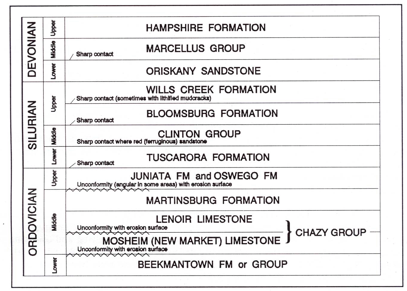 |
| Figure 1. Some Well-Known Sharp-Contact Surfaces and Erosional Unconformities in the Central Appalachians. This figure shows only those formations, in each system, which are discussed in this book. Compare Figure 4, which shows parts of the Mississippian and Pennsylvanian rock systems which lie above the Devonian system. |
A few of the many examples of clear, distinct, physical boundaries between formations here in the Central Appalachians4 where I live are given below. Each of these is a clear example of the failure of Morris and other young-earth creationists to familiarize themselves with the sharp* contacts which exist in the strata.
1. The Tuscarora Formation (Lower Silurian) is widespread in the Central Appalachians and crops out extensively in the Valley and Ridge Province (see Figures 1 and 2). Butts (1940, p. 230) says of it, "The lower boundary [lying on the Juniata Fm] is everywhere distinct. The upper boundary is clearly marked where the lower part of the Clinton [Group]* includes ferruginous sandstone, as in the middle portion of the [Appalachian] Valley in Virginia." However, in parts of the Central Appalachians the upper surface of the Tuscarora does have some "thin transitional beds" (Chen, 1977, p. 80). Chen and many other authors refer to the well-known "sharpness of contact" of the Tuscarora Formation in Pennsylvania, Maryland, West Virginia, and Virginia. (See Reger, 1924, p. 417.) The areal* extent of the Tuscarora in these states is more than 70,000 square miles, including the subsurface parts. Approximately one third of this consists of thick beds of almost pure quartz sandstone (or quartzite, depending on the amount of metamorphosis). The thickness of this quartz or quartzite is a few hundred feet in broad areas of Pennsylvania, Maryland, and West Virginia.2. The Clinton Group, above the Tuscarora Fm, has approximately the same areal extent as the latter, and, in the many areas where it contains the ferruginous (red) sandstone formation, the boundaries of contact with both the underlying and overlying formations are nearly always sharp and clearly defined (Chen, 1977, pp. 86, 87, 90, 91; and Reger, 1924, p. 409-413). In some areas this red sandstone rests (with a sharp contact) upon the lower formation of the Clinton Group instead of on the Tuscarora, thus producing up to four sharp-contact boundaries in vertical sequence, all within the lower part of the Silurian age strata.
3. The lower contact surface of the Bloomsburg Formation (Upper Silurian) of Pennsylvania, Maryland, and West Virginia is frequently sharp and definite over wide areas (Chen, 1977, p. 92; Reger, 1924, pp. 389, 394; Hoskins, 1961, pp. 26ff). Also, the contact of the upper surface of the Bloomsburg with the Wills Creek Formation is sharp, at least in northeastern West Virginia. Not only this, but there was such a change of environment that desiccating conditions developed and persisted for a considerable time before the Wills Creek Formation could be added. This is evident from the "numerous mud-cracks" at this level. (Reger, 1924, p. 389)
4. The Oriskany Sandstone (formation, Lower Devonian), which covers a broad areal extent in West Virginia, Maryland, Pennsylvania, and New York, is well known for its sharp formational boundaries, described in oil and gas geology publications and elsewhere. The Oriskany Sandstone is deep in the subsurface of most of West Virginia, but in the eastern, uplifted mountainous sections it crops out in many places. The usual types of exposure are described by Reger:Examples of sharp contacts between formations, and also between "members"* of formations, are so abundant that the authors of works on stratigraphy usually do not even bother to mention them—so we will not cite any more here. However, in closing this section we would remind our readers that in at least most cases of sharp-contact surfaces, the lower formation of the two had to be significantly lithified before the next was added, in order for the boundary to be distinct. We must therefore conclude that the rock strata do not offer any support for the hypothesis of rapid and continuous deposition which is promoted in young-earth creationist literature. In each case men tioned above—and in at least most cases which are known—there is every indication that the lithification* was by the normal, slow cementation processes (which are described in the section "Neglect of Data Concerning Rock Lithification," later in this book).At its base the group herein classified under the general name Marcellus rests upon the coarse and massive Oriskany Sandstone, the change from black or gray shale to sandstone being abrupt without any interbedding or transitional sandy material. In addition to the change in lithology [rock type] there is a corresponding difference in fauna,* as shown by lists published in chapter XXI. Both of these factors indicate a considerable unconformity. . . (Reger, 1924, p. 317).
It is also helpful to remember that there are a multitude of
examples
of surfaces withinsome kinds of formations which show that
there
were significant periods of exposure of the rock surface before further
deposition took place. There are, of course, the erosion surfaces
mentioned
above, but there are also other time-indicating surface types buried in
many local* sedimentary columns. Polygonal mud-crack surfaces are one
such
type. In these, the fine sediment of a mud flat along a seacoast dries
out until the mud shrinks and is broken into polygonal blocks of from
several
centimeters to more than a meter in diameter. Later the entire area is
buried by another layer of sediment (usually during a storm or
tsunami*),
and thus is preserved.
 |
 |
 |
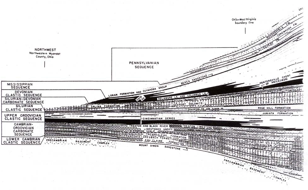
| Figure 2. A Vertical-Section Diagram Through the Central Part of the Appalachian Highland Region. This diagram extends approximately west-to-east, beginning in Ohio and ending in western Virginia. In this "vertical map" we get a summary, perpendicular view of what the geological strata of this area would look like if one could view all of them at the same time, from the south looking northward. Note the thickness scale at the left of the diagram and the labelling of the geological Periods and Systems at each edge of the figure. All of the systems from Precambrian up through Pennsylvanian are present, and in the expected order, in most of West Virginia. These have been verified in this geographic area by drilling records from thousands of deep wells, and also by many detailed seismic surveys. Most of the labels within the diagram itself are the names of geologic formations which make up the various rock systems. From Studies of Appala chian Geology: Centraland Southern,by George W. Fisher, F. J. Pettijohn, J. C. Reed, Jr., and Kenneth N. Weaver, eds. This diagram is Figure 2 of the book, and is entitled "Stratigraphic relations of the basin fill." Copyright 1970 by John Wiley and Sons, Inc., and reprinted by their permission. |
Very often, in both recent and ancient strata, such polygonal mud-crack surfaces contain the remains of thick mats of algal* growth. The algae help to bind the mud together, holding the shrunken blocks in their original shape until lithification processes can begin. This process of polygonal block formation has been observed on many seacoasts today, as described in such works as Ginsburg (1975). Bathurst (1975, pp. 202-204) gives a description of how such polygons form in some places on the shores of the Persian Gulf. Algal-mat, polygonal blocks, preserved along with fossilized remnants of the algal mats,* are found in ancient rock formations in various parts of the world. A vivid example of such preservation is shown in James (1979), figure 8. It is a photograph of an area of Upper Cambrian polygonal blocks from the East Arm Formation at the edge of Bonne Bay, Newfoundland, in the Northern Appalachians. In this formation the blocks were preserved with their edges noticeably curled up, "likely because the algal mats in the polygons shrivelled upon exposure and drying out" (caption of James' figure 8, p. 113). Preserved, polygonal-block strata of this type are sometimes found in vertically repeating sequences, showing that there were climatic cycles which brought about a repetition of the desiccative conditions, with a considerable period of time in between.
Some Reasons for the Grading of Various Formations into Those Adjacent to Them
As we observe the edges of two adjoining formations which lie one above the other—as seen in the vertical walls of a canyon or road cut—we often find that the sediments of one grade into those of the other. (By this we mean that there is an intermingling of some of the sedimentary rock particles of one formation with those of the formation which lies either above or below it.) However, this does not mean that a given sediment layer above was necessarily always laid down soon after the one below it—as Morris asserts to have been the case. The following paragraphs cite some of the ways by which a grading of sediments into each other can occur without there being a rapid and continuous deposition of the layers one after the other, as Morris postulates.
There are several depositional conditions which make transitional contacts between strata possible. One of these is the common circumstance in which sediments are deposited, partially lithified, and then eroded in such a way that the sediment particles which are being removed from the first layer are incorporated into a second layer which begins to cover the area. Thus, the upper boundary of the first layer becomes blurred or indistinct as the sediment layer above it is added. This is often a part of the natural depositional process, because the depositing of silt, sand, and gravel is always accompanied by the expenditure of considerable amounts of energy by moving water or wind. Since firm cementation of rock particles usually requires at least several hundreds of years, the exposed surface of a given deposit is easily disturbed and partially broken up by wave action when a new depositional cycle begins. This process is frequently observed on arid seacoasts today, where components of an earlier deposit become incorporated into a new layer. In this way a gradational or transitional effect is produced.
In any depositional basin where there has been a return of the sea and a resump tion of normal deposition, mixing actions such as this are more vigorous and extensive at the edges of the basin than in the parts where the water is deeper. This factor is sometimes sufficient to account for the more extensive grading of a given formation at its edges, into the overlying formation, which Morris mentioned in item no. 4. It is only normal that the wave and water-current actions should scour the bottom more vigorously at the edges of the basin (where the waves break) than out where the water is deep.
Of course in many cases sediment deposition was not resumed until the upper surface of the deposit had become firmly cemented. For example, a formation may have been deposited as a carbonate* beach sequence which prograded out onto the shelf of the basin, moving the shoreline several miles seaward, much like a delta builds out at a river s mouth. If deposition was followed by a temporary drop in sea level, such as during an ice age, the deposit would be "left high and dry." When the sea level rises again, the deposit might get covered by subsequent beach deposits. This is what we see in cyclic carbonate deposits like the Conocochegue Formation of western Maryland. In such situations we will find either (1) a sharply defined contrast or "contact" between the two formations, or (2) the marks of erosion on the hard rock surface at the top of the first formation accompanied by a small amount of mixing of the old components with the new. This principle is evident in the examples of erosion which we will cite in the succeeding pages.
A very helpful, and seemingly valid, model* which is invoked by most sedimentary geologists for explaining the grading of sequences of strata into each other in many parts of the world is given in the Appendix of this book. This model not only offers an explanation for the grading of many formations into each other, but also includes a very reasonable solution for the problem of why stratigraphic time boundaries often cut across formational boundaries. (The latter is a phenomenon which Morris has misunderstood—as in Morris and Parker, 1982, pp. 203-205.)
Some Examples of Ancient Erosion in the Sedimentary Cover of the Earth
The results of erosion found between the sedimentary strata at various levels in many local* sedimentary columns in the United States, Canada, Europe, and Australia are so well known and thoroughly described in the literature of geologic research that it seems almost unnecessary to cite examples. But since large numbers of creationists seem to be unaware of them, we want to give several examples. Each of these is an undeniable indication of the passage of at least many years of time for the erosion of a layer of rock before the next layer above it was added. We will concentrate on parts of the sedimentary cover which are generally thought of by young-earth leaders as having been formed during the Biblical Flood and which are in locations where they obviously could not have been gradually deposited and eroded in post-Flood times.5
1. Carbonate Hardground Surfaces
In many of the carbonate (limestone or dolostone*) rock layers of the world we find "hardground surfaces." In such cases the layers of rock have visible characteristics on their upper surfaces which show that each such surface was exposed to at least some scouring, dissolution, or other alteration after it was lithified and before the succeeding layer of limestone was added above it.
Since these hardground layers are marine* in origin, many of them have an abundance of marine fossil shells embedded in the limestone. Commonly, in such a layer, the shells which are at the upper surface are extensively eroded (truncated) so that only one half or less of the shell remains—solidly embedded in the hard limestone. Since this rock layer was lying in water while the erosion was going on, encrusting-type, lime-secreting, marine animals (such as oysters) are frequently found on the eroded surfaces. Also many of the eroded surfaces have been "bored" by sponges and other types of marine animals which bore holes in the rock by a process in which they secrete acid which dissolves the carbonate rock. The inner surfaces of these "bored" holes frequently contain the truncated remainder of component grains* of the rock which were cleanly cut off by the animal as it advanced deeper into the rock (Bathurst, 1975, pp. 373 and 395-397; Wilkinson, et al, 1985, pp. 171-173). (See Figure 3.)
It is very evident that all of these processes of change in the upper surface of the layer required several years of time. And one must not forget that an extended period of time was required for cementation of the carbonate grains into the form of a hard layer before these processes of erosion, encrusting, and boring could begin. In the rock record where vertically repeating, successive layers of such hardgrounds are found, it is obvious that a change in the environment on the sea floor eventually brought in sediments fast enough to bury and preserve the organisms which had encrusted the limestone layer. Then, after from a few centimeters to more than a meter of these loose sediments were brought in, more carbonate sediments were produced and cemented into a second hardground layer. In this way repeating successions of the alternating hardgrounds and softer intercalating sediments were built up over relatively broad areas outward from the seacoast.
Hardgrounds can be observed in limestone formations in the Appalachians and in other parts of the United States and Canada. Also, the process of hardground formation which is actually going on today has been observed and described in various parts of the world. For a long time the development of hardgrounds in modern carbonate environ ments of the world went unnoticed because it is a rather slow process. But now there are better methods of observation, and so the rates of growth, boring and erosion have been measured in a good number of shallow-water marine areas (Bathurst, 1975, pp. 371, 374-375, 381-382; 1983, pp. 355-359).
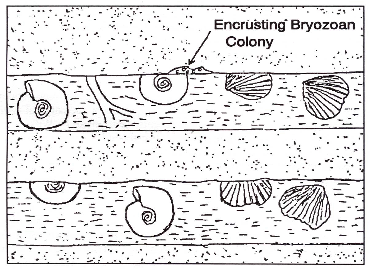 |
| Figure 3. Diagram of a Vertical Section of Two Carbonate Hardground Layers and the Sediments Between Them. Note the shells which were cemented into the limestone surface on the sea floor and then eroded off before the next layer of sediment was added. On the upper hardground surface a colony of bryozoans is building a calcium carbonate deposit over the remainder of a shell which was earlier subjected to erosion. This is typical of the incrustation found on ancient carbonate hardground surfaces in many parts of the world. |
Some of the best examples of older carbonate hardgrounds which have been formed in ancient rock systems on the continents are the following.
(1) A formation of Jurassic limestones of Lorraine in France containing 30 to 40 hardgrounds, with many encrusting and boring organisms represented (Jaanusson, 1961, p. 228; compare Bathurst, 1975, p. 396, Fürsich, 1979, p. 27, and Purser, 1969). Fürsich (1979, pp. 3-9) lists over 30 locations in Europe where Jurassic hardgrounds are located, and gives references for the descriptions of them.(2) A Devonian formation in Russia in which hardgrounds with "a rich epifauna* ... occur at many different levels" (Jaanusson, 1961, p. 227).
(3) An Ordovician formation in Sweden, slightly over 6 meters thick, containing a succession of fossiliferous hardgrounds, with the beds being from 2 to 20 cm thick, with marl or shale between them (Bathurst, 1975, pp. 397-399).
(4) Hardgrounds of Middle Ordovician limestone sequences in southwest Virginia (Read and Grover, 1977, pp. 961-963). These exhibit encrustation by bottom-dwelling marine organisms such as bryozoans. Also most of the hardground surfaces are impregnated by brown-to-black opaque minerals which obviously accumulated on them by precipitation before they were covered over by the next succeeding layer. In this Ordovician limestone the hardgrounds "are commonly multiple, several occurring within one meter [of thickness]" (Read and Grover, 1977, p. 962).
(5) An excellent example of a Jurassic carbonate hardground sequence here in the United States which has been carefully described and studied in detail is that found in the Sundance Formation of southeastern Wyoming. The main description of the stratigraphy, lateral distribution, and general petrology of this hardground sequence is by Andersson (1979). A thorough study of the petrology, inferred depositional environments, and cement types of this formation has recently been made by Wilkinson, Smith, and Lohmann (1985). This latter study carefully investigated the cement crystals which were formed during early lithification (i.e., before erosion and burial) of at least nine of the hardgrounds in the vertical sequence found in this part of Wyoming. One particular layer of these hardgrounds was identified at several widely separated sites covering an area of approximately three thousand square miles.
2. Some Ancient Erosional Features of the Grand Canyon of Arizona
One of the areas in which the eroded upper surfaces of ancient buried strata can be readily observed is in the Grand Canyon. On the upper surface of the well-known Redwall Limestone Formation of this canyon there are extensive, ancient erosional features left from the period of time (end of the Mississippian) when this great area of limestone was exposed to weathering. Since this is limestone6 it was prone to the development of caves, caverns, and sinkholes during the time it was exposed, before the rock formations above it were deposited. These erosional features are characteristic of karst* topography which is even now in the process of development in parts of the world where limestone formations are at or very near the surface. Such areas of karst development are common in parts of Kentucky and Virginia.
Before describing the karst development of the upper part of the Redwall Limestone we should mention that there are definite erosion surfaces both at the base of this formation and farther up, about one-half way to the top. The definite unconformity at the base of this formation, where it rests on the Devonian Temple Butte Limestone, was noted as early as 1880 by Walcott. Since that time a good number of geologists have studied this contact and have identified various kinds of erosional features there. McKee and Gutschick carried out very extensive and careful research of the nature and depositional conditions of the entire Redwall Limestone formation. They describe the erosional basal contact of the formation which we have just mentioned, and also include eight to-scale diagrams of some of these very distinct types of erosional structures which they observed (McKee and Gutschick, 1969, pp. 15-17, 24, 614-619, 625-628). Their study also revealed similar, distinct features of erosion at a higher level in the formation between the Thunder Springs Member* and the Moony Falls Member which rests upon it. McKee and Gutschick (1969, pp. 49-52) describe this erosional unconformity and give seven to-scale diagrams of the ancient erosional structures at this level in the Redwall Limestone which have been uncovered in Kanab Canyon, Marble Canyon, Havasu Canyon, and other sites. (The reader should understand that the uncovering of the ancient erosional features has been accomplished by modern erosional processes.)
The extensive eroded surface at the top of the Redwall Formation is even more spectacular than those which we have just been discussing, and was more extensively studied and described by McKee and Gutschick as well as other geologists. The karst topography cavities and channels of this eroded surface, which we mentioned above, extend far back away from the canyon itself. Just as with other erosion surfaces at the lower levels, more cavities become exposed as the canyon is progressively worn further back into its banks. (The Redwall Formation extends for over 175 miles north to south and more than 275 miles east to west, being known from many drilling records and seismic surveys.*)
It is evident that the original period of erosion on the top of the Redwall Formation was at least several thousand years in length, as some of the solution cavities which formed in the already well-cemented limestone are large and complex. Another clear evidence of this is the abrupt blocky knolls which were left standing on the ancient limestone landscape and later buried by the addition of the Supai Formation. These knolls (or small mesas) are periodically exposed as the canyon wall widens. They range up to 40 feet in height and are composed of limestone which, at the time of the ancient erosion, was more resistant to weathering than that which was around it, thus with standing the erosion process.
After the erosion of the ancient landscape had progressed to the karst-blocky knoll stage, conditions for sediment deposition (rather than erosion) were restored, and the remaining 2,000+ feet of rock layers were added. During the early stages of this later deposition, the solution cavities of the Redwall Formation were filled in with non-marine,* clastic sediments of the Supai Formation which was being deposited above the Redwall, and the blocky knolls were buried by the same. There is a good description of these cavities and knolls in McKee and Gutschick (1969, pp. 74-85, 563-564). They have included several to-scale diagrams of the ancient erosional features which have been found uncovered at various locations at the top of the Redwall Limestone (pp. 78-81). Also included are photographs of some of these, taken in the field (pp. 94-95). There is a simplified but fairly inclusive summary of their findings on the Redwall Limestone in Wonderly (1977, pp. 140-145). The young-earth creationists' omission of information concerning the erosion surfaces of this well-known formation has misled large numbers of people into thinking that all of the Grand Canyon strata could have been formed rapidly.
We would be guilty of extreme negligence at this point if we were to fail to mention the significance of the main bodyof the Redwall Limestone formation. Here is an enormous expanse of unusually pure limestone (most of it over 98% CaCO3 and CaMg(CO3)2) which has a thickness of 500 to 700 feet. It is abundantly supplied with marine fossils—in stark contrast to the formations which lie directly above it, only two of which possess any marine fossils. Furthermore, there are many layered, in situ* growth mats of fossilized, lime-secreting algae embedded in the rock in the normal position in which the mats grew (McKee and Gutschick, 1969, pp. 104, 554, and plate 15). No amount of speculation can produce a rational, one-year-Flood explanation for such a geologic formation. To suppose that it was precipitated* rapidly out of the ocean water is utterly unreasonable for the following reasons: (1) supersaturated* ocean water cannot contain or release so much CaCO3; (2) the fossils obviously were not precipitated; and (3) the Flood was (according to "Flood geology") a convulsive event, not able to permit the settling of 500 feet of pure CaCO3 and CaMg(CO3)2. It is also utterly unreasonable to postulate that the components of this great body of limestone were concentrated and washed into place by the Flood, because: (1) any hydraulic cataclysm which could bring about such a massive transport as this (in the short time allowed) would mix the carbonate shell materials and other grains with many foreign kinds of rock components; (2) there is no way in which in situalgal growth mats could develop during such a high degree of agitation; and (3) if they were somehow to develop, they and the many other delicate fossils of the formation would have been crushed by the immediate adding of the huge weight of one-half mile of sediments dumped on top of them before there was time for even the beginning of the rock cementation process.
Most creationists seem to be unaware of these and other enormous problems which make the "Flood geology" explanation of the earth's sedimentary cover completely incompatible with the large amounts of carefully collected data now available. As Christians we should all feel a solemn obligation to collect and use the available data before formulating a hard-and-fast opinion as to how the earth's crust was formed. There is an abundance of carefully collected, published data readily available for studying the Redwall Limestone, and creationists who discuss the Grand Canyon have an obligation to use it.7
Those who believe that superficial, non-microscopic studies can sufficiently reveal the nature of the Redwall and other similar rock formations are like the person who might concentrate on the gross anatomy of the human skeleton while denying the validity of microscopic anatomy. It is possible to make an elaborate and high-quality study of the various bones of the human body, only describing the mechanical structure, strength, and function of each. Such a study, however, can never reveal the nature of the solid bone substance or how it was formed. Without microanatomy the student will invariably assume that bones are homogeneous, solid material, and will know nothing of the living cells (osteoblasts) which have been responsible for the production of the bone; and that all of these cells are constantly supplied with food, oxygen, and minerals by a complex microscopic network of blood vessels which permeate each cubic centimeter of bone.
Thus no amount of high-quality study of gross skeletal anatomy, or of the chemical nature of bone, can enable the student to learn how the bone was formed. If he wants to know this, he must become willing to use the information provided by microanatomy. Similarly, no amount of study of gross stratigraphy or the chemical nature of limestone layers can reveal the means by which those layers were formed. For that, one must make microscopic petrological studies to find the marks and structures left by organic growth and by the cementation processes.
3. Examples of Ancient Erosion Which Are Observable in the Appalachians
In the Central Appalachians there are from 3 to 5miles of thicknessof Cambrian to Pennsylvanian sedimentary layers. This is from three to five times the thickness of the Grand Canyon strata. A summary of these strata systems in the West Virginia-Maryland area is given in Figure 2. Because of the great amount of folding during mountain building, followed by extensive faulting and erosion processes, most of the formations of this great array of sedimentary systems are now exposed at various places, clear down through the Ordovician, and they can be studied where they crop out along the mountain ridges and elsewhere. The contacts of many of these formations are very often sharp and distinct, and in some places the marks of ancient erosion of the upper surface of a formation can be clearly observed when the formation above it is removed, as in a rock quarry. The observation of erosional features in this manner is possible in many parts of the world, and reference is made to them in the literature of stratigraphy and sedimentology. Yet Morris and his colleagues have neglected such features and leave their readers to suppose either that they do not exist, or that they are unimportant.
(a) The oldest well-known erosional level which is widespread in the Central Appalachians is that found at the top of the Beekmantown Formation or Group (Lower Ordovician, Fig. 1). This formation is composed mainly of limestone and dolostone, and extends throughout most of West Virginia, western Maryland, central and western Pennsylvania, western Virginia, and eastern Tennessee. Most of a NE-SW band of it, 100 miles wide along its eastern extent, is at least 1,500 feet in thickness, and much of it is 2,500 feet or more.8 In much of this area the Beekmantown has been observed to have extensive erosion features on its upper surface where the overlying formations contact it. Butts (1940, pp. 119-120, 135-136, 139, and 168) refers to this great erosional unconformity as he has observed it in various counties of Virginia. Any unconformity* of this type and extent represents the passage of many years of time—probably hundreds of thousands of years—before the next layer above it was added.
The magnitude of carbonate dissolution and erosion of the previously cemented rock layers of this unconformity at the top of the Beekmantown Formation is dealt with in detail by Mussman and Read (1986). They point out that the erosional relief (vertical variation due to erosion) of this unconformity is as much as 140 meters in southwest Virginia (where it is called the "Knox Unconformity"). The erosional relief gradually decreases northward (parallel to the Appalachian mountains) to only a few meters in the northern part of Virginia (Mussman and Read, 1986, pp. 283-284). In Middle Ordovician times dissolution and erosion modified the basal strata of the unconformity—which strata are composed of limestone and dolostone—leaving various karst features, including knolls, stream channels, sinkholes, and caves. Concerning the length of time required for this, Mussman and Read state: "Given that rates of carbonate dissolution in karst terranes range from 10 to 100 mm / 1000 yr (Sweeting, 1972), from 1 to 10 m[illion] y[ears] would be necessary to form the observed unconformity relief." (1986, p. 283). There are several sedimentological and petrographic* indications that most of this dissolution occurred during periods when the previously-cemented limestone was exposed above sea level—probably during the Taconic Orogeny. For example, the preserved, ancient sinkholes and caves closely resemble many of the same found in present-day karst terrane in Florida, Tennessee, and Kentucky, and most of the Ordovician ones studied by Mussman and Read were filled with nonmarine, nonfossiliferous sediments. The authors state:
As for the ancient caves observed in the unconformity by Mussman and Read, all of them were filled with nonmarine, nonfossilferous sediments. It is very significant that, in both the sinkholes and caves, the contact between the cavity walls and the body of sediments which had been brought in later was everywhere found to be sharp or distinct (1986, pp. 285-286 and Figs. 10 and 11). This demonstrates the fact that the limestone in which the cavities were formed had been thoroughly cemented into hard rock long before the main filling process was begun.
If one wonders how these and the other ancient karst features of the Beekmantown unconformity can be observed in the field, and why they have not all disappeared by weathering and erosion, here is the main reason: The Middle Ordovician rocks in which these features were found were buried by additional formations of rock which were added after the erosional period had ended, and so have been protected from further weathering. Because of uplifting and faulting, especially during the later orogenies, certain parts of the unconformity were exposed (and worn away) while other parts remained in positions of burial such that they are only now being exposed and worn away. These latter exposures are now observed by field studies, with their ancient, filled-in caves and sinkholes seen in various stages of exposure. Thus we have a situation very similar to that described above for the upper part of the Redwall Limestone of the Grand Canyon. In both cases, modern erosion is exposing the ancient karst features and infillings which were deeply buried by the addition of later formations added above them.
Not only is there the erosional unconformity precisely at the upper surface of the Beekmantown Formation, but on up in the next group which covers it (the Chazy or Stones River Group), another is found. Thus, Butts (1940, p. 136) says, "The quarry at Marion, Smyth County, shows a pronounced erosional unconformity [at the upper surface of the Mosheim Limestone, which lies directly on the Beekmantown]." The Mosheim Limestone is usually from 30 to 100 feet thick in Virginia, and is covered by the Lenoir Limestone (Fig. 1). In the caption of a photographic plate showing the eroded surface of the Mosheim Limestone, with the Lenoir naturally resting on it, Butts states, "Irregular contact of the Mosheim limestone (below) and the nodular Lenoir limestone. This kind of contact of the two formations has been observed at several places in the Valley [Appalachian Valley of Virginia] through a distance of several hundred miles." (Butts, 1940, p. 168). On p. 139 he says concerning this, "... the irregular contact surface of the Mosheim, caused by pre-Lenoir erosion [of the Mosheim Limestone], which resulted from pre-Lenoir emergence, indicates a considerable hiatus in some areas." (Butts, 1940). The ancient erosion marks of this and similar contact surfaces, which are observed when they are uncovered, could have been made only in rock that has been at least moderately well cemented. Read and Grover (1977, pp. 957-961) describe this erosional unconformity at the top of the Mosheim Limestone (now called the New Market Limestone) in more detail and name other places in Virginia where they have observed it.
(b) In the Middle Ordovician there is another well-known erosion surface at the top of the Martinsburg Formation (Fig. 1). This is described as follows in Guidebook:47th Annual Field Conference of Pennsylvania Geologists(1982, p. 26):
This angular unconformity, as it exists in the Valley and Ridge Province of eastern West Virginia, is described by Reger (1924, pp. 424, 427):
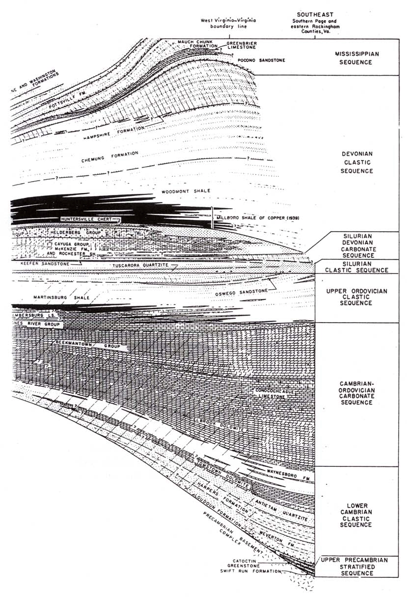
(c) When we go on up to the Mississippian strata System in the Central Appalachians (see Figs. 1 & 2) we find at least two definite levels of erosion surfaces. The lower one of these is at the base of the Lower Mississippian Pocono Group. Reger (1924, p. 282) observed that the Pocono in eastern West Virginia "rests unconformably on the oxidized red shales of the Catskill Series of the Devonian Period, a long lapse of time and wide exposure to aerial and erosive action being apparent." (See Fig. 4).
(d) In the Middle Mississippian is a rather thick deposit of highly fossiliferous, definitely-marine limestone. It is called the Greenbrier Limestone (Fig. 4) and underlies approximately 75% of the state of West Virginia, and parts of Pennsylvania, Maryland, Virginia, Kentucky, and Ohio (Flowers, 1956, p. 3). In the southernmost counties of West Virginia this formation is from 500 to 1200 feet in thickness, but farther north and west it tapers to between 100 and 200 feet, and occasionally less (Flowers, 1956, pp. 14- 15). A considerable percentage of the thickness in the southern counties is made up of shales and sandstones—though most of the shales are calcareous *.
It has been known since 1956, when Flowers published his report on the Greenbrier Limestone, that a major part of this formation exhibits pronounced erosional features at its deeply buried upper surface. In fact, in a few areas of northwestern West Virginia, the entire thickness of the Greenbrier was eroded off in an irregular manner, leaving only a few isolated knolls of the formation. By means of well drilling records and seismic surveys, personnel of the West Virginia Geological and Economic Survey have been able to trace the course of one major river and several tributaries which cut deeply to form abrupt channels in this limestone formation. The channels are now filled in with non-carbonate sediments of the Pottsville Group (Lower Pennsylvanian) and lie at a depths of 1,500 to 2,000 feet below the surface. The buried channels are described in Flowers (1956). J. K. Filer of the Survey has now completed a more thorough study of these and other erosion features in three counties where this erosion is known to exist (Filer, 1985). Since the time Flowers published his work on the Greenbrier Limestone, this formation has been penetrated by thousands of additional wells. Between 1979 and the end of 1983 the number of new wells drilled through the erosion surface and into the Devonian below in just the three counties mentioned above, was 1,110 (Filer, 1984, p. 39). Also many more detailed seismic* surveys, which are very effective for determining underground contours and thicknesses, have been made.
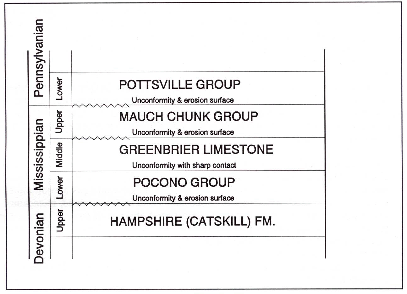 |
| Figure 4. A Sequence of Unconformities and Ancient, Buried, Erosion Surfaces in the Mississippian and Lower Pennsylvanian Rock Systems of West Virginia. |
The West Virginia Geologic Survey's knowledge of this erosion surface is now much more complete than it was when Flowers made his study (Filer, personal commu nication, 1985). The evidence is decisive that the period of erosion was at least hundreds of thousands of years in length. This evidence includes the fact that parts of the Greenbrier Limestone have Mauch Chunk (Upper Mississippian, Fig. 4) non-marine, sedimentary rock layers immediately overlying them, but that the latter were worn thin or (in the western edge of the state) entirely removed by the erosion process (Flowers, 1956, p. 14). Therefore we know that, before the great period of erosion began, there had to be a period of deposition of the Mauch Chunk sediments, and at leastseveral thousand years beyond that for the minimum amount of cementation necessary before the Mauch Chunk strata could be eroded off to the present tapered ("stair-step") form which has been identified by the above-mentioned petroleum explorations. There is just no conceivable way that this type of erosion, and the subsequent cutting of steep canyon walls in the Greenbrier Limestone itself, could have been accomplished while the sediments were still soft and uncemented.
An observation of Reger in the eastern edge of the state further reinforces the conclusion that the upper Mauch Chunk strata lay exposed for a long period of time before the Pottsville Group sediments were added. He describes the contact between the Mauch Chunk and Pottsville strata, in areas where they are exposed in Mineral and Grant Counties, as follows:
(e) Discussion. Concerning the significance of all these examples for young-earth creationism, Morris admits that angular unconformities "may conceivably indicate a long period of erosion," but then immediately adds:
One might at first suppose that major unconformities could be used to note a time-break—perhaps the end of one geological epoch and the beginning of another. The problem with this, however, is that there is no world-wide unconformity! A time break in one region may not be noted in another region at all (Morris, 1974, p. 113).This assertion that erosional unconformities could not have real significance with regard to time unless they were worldwide in extent should be immediately recognized as false logic. Even oneof the many geographic areas which possess a local stratigraphic column with erosional time gaps and other stratigraphic features which demand some millions of years for their deposition and subsequent modifications is enough to show us that at least thatpart of the earth is millions of years old. And since there are actually many such local columns, both in the Appalachians and elsewhere, Morris' claim that the earth's sedimentary strata were practically all laid down "rapidly and continuously" without time breaks is a rejection of these local* columns as they actually exist. Morris tries to justify this rejection by quoting from two geological articles on the subject of geochronology, but the quotations only recommend that unconformities not be used as definitive markersin geological time systems (Morris, 1974, p. 114). The quotations do not imply that the unconformities fail to represent long periods of time in the history of the local stratigraphic columns in which they are found. The authors are merely recognizing that the changes of elevation on the land of the various continents were very naturally limited in their areal extent, and not time-synchronized. It is very well known that the rising and falling of the land areas with respect to sea level was not such that all land areas rose and sank at the same time. Such movements are governed by local conditions of the earth's crust, not by linkage to a worldwide control system.
However, it is appropriate to state here that within a very few years after the publication of Morris' 1974 work, oceanographers, petroleum geologists, and other earth scientists were realizing that recently-made observations in many parts of the world indicate the presence of several interregional unconformities which involve most of the continents. These are largely due to marine regressions during the (now well-catalogued) major global sea-level fluctuations which have occurred since Late Paleozoic* times. Data which strongly indicate the locations of several interregional unconformities are described in Schlee (1984), Ross and Ross (1985), and Saunders and Ramsbottom (1986). Sea level fluctuations often reflect regular climatic changes affecting the volume of ice accumulated at the poles, or changes in the volume of the ocean basins due to movement of the continents. So Morris' claim that there are no worldwide unconformities appears to be unjustified and invalid.
Morris makes a further attack on the significance of unconformities in the book What is Creation Science? (Morris and Parker, 1982, pp. 203-206). Here he attempts to show that, because unconformities in the various strata systems do not always correspond to the chronostratigraphic (time) boundaries which are recognized by geologists, they cannot actually represent appreciable amountsof time. For example, his Fig. 47 has the caption "Inadequacy of Unconformities to Determine Age." The figure is a diagram showing that "unconformity surfaces" are independent of time boundaries which have been established for the earth's sedimentary cover. Morris tries to convince his readers that because unconformity surfaces are not useful for determining theage or geologic time period of the stratigraphic units in which they appear, they do not represent the passage of any significant amount of time. This is very misleading, and evades the real issue, namely the passage of time during the cementation, erosion, and other processes which occurred before the next deposit above the unconformity was added.
In this book we have cited numerous examples of erosional unconformities covering large geographic areas, which show that in each case the area was eroded very visibly after it had acquired at least a moderate degree of cementation. These examples demonstrate clearly that these unconformities dorepresent very appreciable amounts of time—both for the prior cementation and for the erosion, as well as for the subsequent reestablishment of conditions for sediment deposition. Such a sequence of events and processes could not be achieved in a mere few decades, over a broad area, without a major alteration of severalfundamental physical laws, and we have no scriptural grounds for believing that such an alteration of these laws occurred at any time after life was placed upon the earth. So, Morris is completely illogical in asking us to suppose that erosional unconformities do not represent long periods of time which elapsed during the formation of the local stratigraphic sequences in which they occur.
Furthermore, in order to have an accurate picture of what the strata
systems of the earth's sedimentary cover are like, we must recognize
that
a considerable percentage of the extensive erosional unconformities
actually
are located at geological time boundaries. This is the case with the
unconformity
at the top of the Redwall Limestone of the Grand Canyon which we
described
above, and also with most of the unconformities in the Central
Appalachians
which we described as well.
1Words asterisked (*), as this one is, are defined in the "Glossary of Geological Terms" at the end of this book. Each word will normally be asterisked only the first time it occurs, or at the first place where its definition is especially needed.
2This definition of "formation" is based on the section "Geological Mapping" in the McGraw-HillEncyclopedia of the Geological Sciences,1978, p. 295. Definitions of the term vary considerably, but in all cases a formation is a subdivision within a stratigraphic "rock system."
3This book, Scientific Creationism,General Edition, by Henry Morris, was republished in a slightly revised form in 1985. However, practically no change was made in the chapters related to geology and the age of the earth's sedimentary cover. In fact, the page numbers and content are the same in both the 1974 and 1985 editions for all the sections cited in this book except page 130. We consider it appropriate to cite the material from the 1974 edition because it is the work which has had the most influence on evangelical creationists during the past decade. The 1974 edition is widely known since so many copies were sold that it was reprinted ten times between 1975 and 1984.
4The Appalachian Highlands Region is usually recognized as being divided into three parts with respect to north to south. The Central Appalachians include the parts located in Pennsylvania, Maryland, West Virginia, and some of Virginia and New York. This designation does not affect the usual division of the Region into "provinces," such as the "Valley and Ridge Province" and the "Appalachian Plateau Province."
5Let me make it clear here that I am not attempting to support all the time that is usually suggested for the composite geologic column. But we do need to recognize the amounts of time which actually were required for producing the types and numbers of layers and structures which we find in the sedimentary formations observed on the earth.
6The word "limestone" is here used in the general sense, which includes both true limestone and dolostone, a magnesium limestone.
7For some readily available, very helpful sources on the geology of the Grand Canyon, see the Bibliography in The Record of Geologic Time: A Vicarious Trip,by Dale Nations (McGraw-Hill Concepts in Introductory Geology Series, 1975).
8This is shown on maps and
diagrams
in Chen, 1977, pp. 46-49 and 54-55.