


CHAPTER 9
CYCLIC EVAPORITE STRATA UNDERLYING
LARGE AREAS OF THE CONTINENTS
CYCLIC EVAPORITE STRATA UNDERLYING
LARGE AREAS OF THE CONTINENTS
1. Introduction and Regional Setting
In order to assist the reader in more clearly visualizing the nature of ancient evaporite formations which show that they were laid down in natural cycles, we will now consider a typical, evaporite-sealed, oil-producing area in Alberta, Canada. Evaporite minerals—mainly anhydrite* and halite*—were very frequently deposited as a series of rock layers covering ancient carbonate buildups which serve as reservoirs for petroleum. Since evaporite rock layers are practically impervious to the passage of liquid petroleum and natural gas which accumulate in the pores of the carbonate formations, they have effectively sealed these resources into the carbonate reservoirs, preventing their deterioration and escape. Approximately 50%of all the world's petroleum reserves are capped by evaporite layers. Kirkland and Evans state:
As stated in Section 3 ("Organic Matter in Ancient Evaporite Deposits") of Chapter 8, laminated anhydrite (calcium sulfate) deposits are found underlying large areas of Alberta and Saskatchewan, Canada. There are also several other types of bedded evaporites in this same geographic area. Together they make up a geologic unit (in the Middle Devonian System) which is called the Muskeg Formation, in Alberta. The southeastern parts of this formation which extend into Saskatchewan are known as the Prairie Formation. A. M. Klingspor's article, "Middle Devonian Muskeg Evaporites of Western Canada" (Klingspor, 1969) is helpful in understanding the nature and extent of these evaporite strata. He says:
In this article a series of figures (Figs. 13 to 16) show not only
the lateral distribution from the northwest corner of Alberta to the
southeast
corner of Saskatchewan, but also the thicknesses (usually between 400
and
600 feet) along this NW-SE, 950-mile distance. In the geologic
literature
this area is known as the Elk Point Basin (Fig. 7), because
the
earth's crust there sank sufficiently, prior to Middle Devonian times,
to allow the deposition of the thick formation of limestone and
dolostone
which underlies the Muskeg-Prairie Formation (see "basin" in glossary).
This underlying carbonate formation, which includes a large number of
true-coral
reefs and other organically-built carbonate mounds in its upper parts,
has been named the Keg River Formation in Alberta, and the Winnipegosis
Formation in Saskatchewan. It is this formation which contains the
petroleum
reserves of the region—mainly because of the porous nature of the reefs
and other carbonate buildups in it.
For our purposes here we will focus mainly on the northwest part of
Alberta, where a great amount of research has been done on the
characteristics
and precise origins of the different layers of the Muskeg Formation.
Bebout
and Maiklem made an extensive study of these as a part of a larger
study
on the environments of anhydrite deposition. This study was initiated
and
carried out as a joint Imperial and Esso Production Research Company
project,
from 1968 to 1972. (It was in this period of time that most of the
major
studies on the sedimentary characteristics of the northern end of the
Elk
Point Basin were made.) The work of Bebout and Maikiem gave special
attention
to the Muskeg evaporite deposits in the Rainbow and Zama subbasins,
both
of which are in the northwest corner of Alberta (Fig. 7).
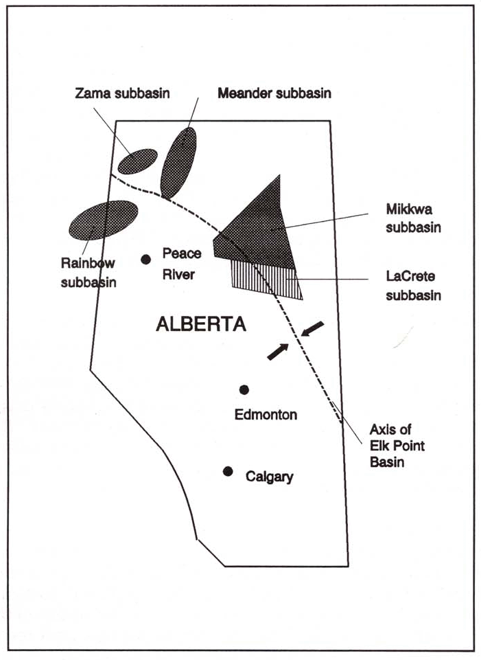 |
| Figure 7. Map of the Devonian, Elk Point Basin, with its subbasins, in Alberta, Canada. (See Glossary for definition of "basin.") These subbasins contain carbonate mounds which are petroleum reservoirs. The carbonate reservoirs lie at a depth of approximately one mile below the surface, in the Rainbow and Zama oil fields, and are sealed over by evaporite layers. Redrawn from McCamis and Griffith (1968, Fig. 2), Bebout and Maildem (1973, Fig. 29), and Davies and Ludlam (1973, Fig. 1). |
2. The Basal Laminites of the Muskeg Formation
The lower part of the Muskeg Formation consists of thinly laminated
anhydrite and carbonate. In most of the thickness of this unit the
laminae
are arranged in couplets or triplets very similar to those of the
Castile
Formation in Texas and New Mexico. (Bebout and Maiklem, 1973, pp.
291-92;
Davies and Ludlam, 1973, pp. 3530-32, 3541-42; Kendall, 1979, p. 160.)
This laminated unit is usually at least ten meters thick over the floor
of the deeper subbasins of northern Alberta, and often laps up onto the
bases of the carbonate mounds in these basins. Sometimes the thickness
is up to 30 meters between the mounds. (Davies and Ludlam, 1973, pp.
3530-31,
3542, and Figs. 3 and 4; McCamis and Griffith, 1968, p. 1909 and Fig.
11.)
The position of these laminated layers can be seen at the base of the
Muskeg
Formation in Fig. 8 of this book, though the figure does not mark the
subdivisions
of the Formation. (Figure 8 shows all of the formations of the Upper
Elk
Point Subgroup, beginning with the Keg River at the bottom.)
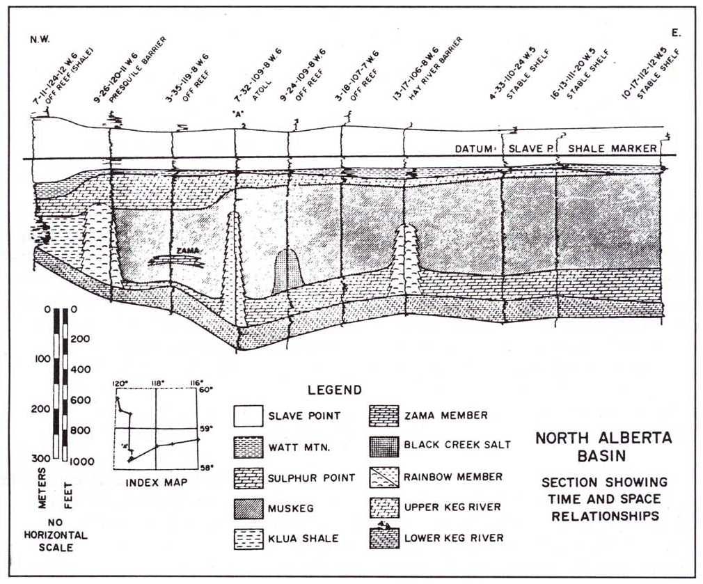 |
| Figure 8. A vertical section through the deeper rock layers of one of the Rainbow area oil fields in Alberta, Canada. The blocks in the "Legend" identify the geologic formations, which appear in their natural order in the vertical section. All of the formations named except the "Slave Point" belong to the Upper Elk Point Subgroup, in the Middle Devonian System. Note the three reefs, shown as white towers with small, curved stipple marks. (These reefs and the beds which surround them are vertically exaggerated in the diagram, so as not to crowd the diagram horizontally . However, their heights are as indicated on the vertical scale at the left.) Ten wells are shown penetrating this vertical section, and are also shown on the small map in the lower part of the figure. Note also that the reefs are embedded, primarily in evaporites of the Muskeg Formation. A part of this thickness is laminated anhydrite. From D. L. Barss, et al., in Geology of Giant Petroleum Fields,M. T. Halbouty, ed., American Association of Petroleum Geologists, Memoir 14, 1970, p. 29, Figure 9. (Reprinted by permission of the America Association of Petroleum Geologists.) |
The couplets in this basal laminated part of the Muskeg evaporites usually are made up of a layer of dolomite or calcite, a dark organic film or layer, and an anhydrite layer. The layers (laminae) in the couplets vary in thickness from a fraction of a millimeter to approximately 1 cm. (Davies and Ludlam, 1973, pp. 3530-32.) There are strong indications that these laminite layers were deposited in relatively deep water—perhaps 50 meters in depth (Davies and Ludlam, 1973, pp. 3541-42). There is also abundant evidence in the core samples to show that the water in these subbasins was periodically restricted as to circulation, and thus extensive evaporation greatly increased the salinity at times, allowing precipitation of the carbonate and anhydrite laminae.2
The organic laminae of the couplets in these laminites show evidence of having been formed from finely divided planktonic algal remains settling into place after the water at the surface became too saline for the algae to grow well. (Compare the discussion on the organic layers of the Castile Formation couplets in Section 3 of Chapter 8.) Davies and Ludlam (1973, p. 3532) cite two careful studies of the organic components of these Muskeg basal laminites; in both, microscopic algal components were found. This, together with the lateral uniformity of the laminae over broad areas (Davies and Ludlam, 1973, pp. 34-35), leaves no doubt that these laminites were laid down cyclicly, in relatively quiet seas which had a high salinity at certain times and a much lower concentration of salts at others.
3. The Limestone Formation and Reefs on Which the Muskeg Evaporites Were Deposited
In order to understand the middle and upper parts of the Muskeg Formation it is necessary to briefly consider the nature of the limestone and dolostone formation which was covered by the evaporites. We mentioned this near the end of section 1 of this chapter, stating that this lower set of sedimentary layers is called the Keg River Formation, in Alberta (Fig. 8). This Formation has been penetrated by hundreds of wells in the Rainbow and Zama subbasins in northwestern Alberta (Fig. 7) and lies at a depth of approximately 5,000 ft in the Zama area. It is composed primarily of types of carbonate rock the components of which are produced in open-marine (not stagnant) environments. The main types of carbonate-secreting macrofossils in it are crinoids, brachiopods, and stromatoporoids* in the lower parts of the formation; and stromatoporoids, corals, crinoids, and coralline algae in the upper parts. (Langton and Chin, 1968, pp. 1930-31; McCamis and Griffith, 1968, pp. 1903-07.) The thickness of the Keg River Formation in the subbasins of northwest Alberta which we are considering varies from approximately 200 ft at the basin edges to 900 ft in the centers. (Hriskevich, 1970, pp. 2261-64).
Since the main oil reserves of this area are contained in the Keg River carbonates (over 2 billion bbl, as of 1970, in the Rainbow subbasin alone [Hriskevich, 1970, pp. 22801), the drilling cores from this formation have been studied in great detail. The upper part of the Keg River Formation, in the subbasins of northern Alberta, includes the ancient coral reefs and other carbonate mounds which we have mentioned above. They are especially good reservoirs of oil, because their organically-built structures include an abundance of pores and cavities which contain the oil. The study of these carbonate mounds made by J. R. Langton and G. E. Chin was a fabulously detailed and systematic research project (Langton and Chin, 1968). As of August, 1967, 56 of the carbonate mounds in the Rainbow subbasin had been drilled, and many more were discovered later (cp. Halley and Loucks, 1980, p. 47). Langton and Chin have carefully described several of these mounds which have all the characteristics of a true coral atoll, including the gross structure and shape, as well as an abundance of specifically identified coral fossils. Those mounds which can truly be designated as reefs rise sharply above the basin floor and contain the proper organically-produced components to show that they grew as wave-resistant structures in a shallow sea (Fig. 8). Several of them rise to a height of 800 feet above the basin floor. Some are merely conical in shape, while others developed the shape and structure of various living coral atolls in the Pacific Ocean. (Langton and Chin, 1968, pp. 1930-43.)
Identification of the characteristics of these reefs was made by a detailed study of cores from 45 of the wells which penetrated them, with 15,000 linear feet of polished core slabs being studied under binocular microscopes, and by extensive seismic surveys (Langton and Chin, 1968, pp. 1928-29). It was of course necessary to study the actual reef cores to determine the organic make-up and types of cementation* found in the reefs, but the shape, size, and slopes of the reefs were determined from seismic* survey reports. Seismic methods are very accurate for determining these characteristics of limestone and dolostone structures.
Actually, most of the carbonate mounds in the Rainbow subbasin were found to have true reef characteristics. Langton and Chin classified them into four basic types, "large pinnacle reef," "small pinnacle reef," "large atoll reef," and "crescent atoll reef." These types are described in Langton and Chin (1968, pp. 1937-43). Schmidt, et al., comment on the larger atoll reefs in the Rainbow subbasin as follows:
At this point we should mention that Schmidt, McDonald, and McIlreath (inHalley and Loucks, 1980, pp. 43ff) emphasize the role of early carbonate cementation* in the production of the reefs in the Rainbow subbasin. The language used by these authors might at first sight be taken to mean that they do not accept these as true reefs which actually grew in the basin. This is not at all the case, as will be seen from a study of pages 45-52 of their chapter. These authors cite most of the sources which I have been citing, and readily recognize that the reefs were growing naturally in the Rainbow subbasin; and also that many of the organisms producing them were wave-resistant "builders." Schmidt, McDonald, and McIlreath call these atolls and some of the other reefs in the Rainbow area, "cementation framework reefs" (p. 48) and explain that early cementation "transformed mechanically deposited skeletal carbonate sediments [which had slid partway down the reef slopes] into wave resistant rocks before they were covered by intercalations* of evaporitic carbonate" (p. 51). The study made by these authors had to do mainly with the upper one-half of the atolls and pinnacle reefs which are found in the Rainbow subbasin. (It was the upper one-half, approximately, of these reefs which was subjected to extended growth-stoppage periods.) What was obviously different and distinctive about the growth of these reefs, as compared with the reefs now growing in the modern oceans, is as follows. During at least the latter half of the time the Rainbow area reefs were developing, there were periods when the water became too saline for the reef to continue to grow, because of the relatively shallow nature of the seas in that area and high rates of evaporation.
These conditions are definitely recognized in the sources we have been citing regarding the reefs in Alberta. The presence of the intercalations of evaporitic sediment at various levels as one progresses upward along the reef slopes gives clear testimony to the fact than an evaporitic environment developed several times during the reef growth. (Remember that the evaporite "laminites" which were described in section 2 above were being deposited during these times of hypersaliity.) Each time a high-salinity phase occurred, the productivity of most if not all of the organisms growing on the reefs was curtailed and the calcium carbonate parts which had already been built, and were exposed by the low water level, began to disintegrate and break loose. Thus, there was much gravitating of reef fragments from their original location to sites from one to a few meters down the reef slope. These fragments were then cemented3 into a permanent position on the edge of the reef, because they were now submerged in an environment which promoted high rates of cementation—as is observed on arid coasts today. Of course this does not mean that all of the original skeletal framework was broken up, but at these times of non-growth a great amount of damage was done to the coral and other skeletal structures which had been formed.
Thus Schmidt and his colleagues, by emphasizing the cementation which took place during the periods of high evaporation rate, have helped us to understand how the coral reefs and other carbonate mounds of northern Alberta could keep on becoming thicker in spite of the periods of high salinity which plagued them. During periods when conditions were favorable to the growth of the reef organisms (which we have named in previous paragraphs of this section) wave-resistant reef material was added. Then when "hard times" came, much of this newly built skeletal carbonate underwent partial deterioration and traveled down-slope to where it could be firmly cemented in position as a part of the reef. The petrographic* studies of Schmidt, McDonald, and McIlreath, and the earlier studies of Langton and Chin (1968) and of Machielse (1972), have identified many well-core components from the reef edges and slopes which bear out the reality of this description. However, the earlier authors did not study the types of cement with which the reef fragments were bound together sufficiently to realize that a high percentage of the cementation was that of an evaporitic environment, rather than the usual cementation which binds the parts of a growing reef together. Also, the work of Schmidt and his colleagues has made possible a better understanding of the evaporite mineral layers which are found penetrating the sides of the reefs as intercalations at various levels. These were laid down while evaporite deposition was going on and the growth of the living organisms of the reefs had become curtailed because of the high salinity.
The tendency of young-earth creationists to deny the reality of these and other ancient, buried coral reefs which are found in the subsurface of many oil fields of the world is very difficult to understand. H. Morris has published the statement, "As far as coral reefs are concerned, it should be realized that fossil 'reefs' are probably not reefs at all" (Morris, 1983, p. 8). He then cites two different authors who have commented on the well-known "Capitan Reef" of Texas and New Mexico, pointing out that it is not a true coralreef (since there are relatively few fossil corals found in it). However, neither of these authors denies the existence of the true coral reefs we have been describing above, or of those in the Michigan Basin and in other oil producing areas of the world.
Morris states further, "A true coral reef contains the binding framework of the coral organisms themselves. Fossil reefs, however, are 'inorganically' bound, not 'bioconstructed.' That is, the evidence indicates that coral and other fossil organisms were simply transported into place by sedimentary processes . . ." (Morris, 1983, p. 9). Obviously Morris was completely unaware of the many research reports describing true coral reefs, buried in the oil fields, which dohave organic binding framework. No scholar or serious student who knows the characteristics of these ancient reefs which have been described in so many high-quality, objective research reports could reject them as myth or imagination. These are notstructures or models which have been produced on a computer screen. They are real, with real fossilized communities of framework-secreting, marine animals and skeletal algae which formed solidly interconnected masses of calcium carbonate. (See above, in this section, for references.)
It is extremely difficult to ignore the reality of approximately 100 well-formed atoll and other conical coral reefs in the Rainbow subbasin alone, nearly all of which are isolated bodies rising above a basin floor which is composed of entirely different carbonate and evaporite layers. In fact, there is a feature of rock distribution around these conical reefs which even further supports the obvious fact that each reef grew as a distinct entity and retained its position and basic shape until it was later covered over. Barss refers to this feature, explaining that the many drillings in the Rainbow area have shown that the reefs have reef-derived detritus (skeletal reef parts) around their bases, but that such detritus is not found in the areas of the basin betweenthe reefs (Barss, 1970, p. 35).
Those young-earth creationists who refuse to believe in naturally-formed, distinct reefs, buried in the oil fields, should also consider the reef characteristics cited in the following quotation from Noel P. James:
4. Desert-Coast Evaporite Cycles Covering the Reefs
A study of the Muskeg Formation, and of the surfaces of the reefs which are being covered by it reveals a recorded history of the progressive desiccation and burial of the reefs, after extreme evaporative conditions developed in the area. Schmidt, McDonald, and McIlreath (1980) cite very strong evidence that this desiccation and burial of the Rainbow area reefs involved several major evaporative periods during which typical evaporitic diagenesis* took place. By a great deal of petrographic* research on specimens from various parts of the reefs they confirmed the earlier observation of Langton and Chin (1968, pp. 1943-44) that the early diagenesis during evaporative phases included not only evaporitic cementation of the limestone of the reef, but also extensive dolomitization* of that limestone. (Schmidt, et al., in Halley and Loucks, 1980, pp. 50- 55.) Thus the sides of the reefs were becoming dolomitized progressively during the times that the above-mentioned intercalations of anhydrite were being incorporated into the outer parts of the reefs.
Bebout and Maiklem (1973) made a thorough study of evidences for the environmental changes (from marine to evaporitic, etc.) which took place during the time when the Rainbow area reefs were being covered by evaporites. They make the following summary statement:
The presence of stromatolites on the exterior parts of these reefs is of great significance. The stromatolite rock layers were built onto the sides of the reefs during periods when the water was low but not too saline for the algae which produce them to grow. (See the section "In SituGrowth Structures..." in Chapter 2 of this book concerning stromatolites and the individual stromatoids* which are found in them.) Distinct algal filaments of some of the stromatoids of the Rainbow reefs have been found in a moderately good state of fossilization (Machielse, 1972, pp. 202, 204). The beds of stromatolites in the Rainbow area are found only on the sides of the upperparts of the reefs, which are the parts that formed during the alternating marine and evaporative periods, and the thickness of the stromatolite beds ranges from "very thin" to 25 feet (Machielse, 1972, p. 204). The stromatolites are found only on the outside of the reefs and "do not occur interbedded with the reef sediments; they are not present within the central part of the reef complex" (Machielse, 1972, p. 207 and Fig. 7). This shows that at least most of the stromatolites were forming only "during periodic cessations of reef growth during which a lowering of sea level occurred" (Machielse, 1972, p. 207)_and this is a well-known, normal characteristic of stromatolite growth of modern seacoasts.
The drillings in the Rainbow oil fields revealed that this unit
includes
successive sabkha-type* cycles of evaporite layers extending across the
subbasin and over most of the ancient reefs. ("Sabkha" is the Arabic
term
for a salt-encrusted sedimentary flat, along an arid coast.) These
sabkha
cycles of the Muskeg Formation are of profound significance in
revealing
the types of environment which existed during the time that the Rainbow
subbasin was being filled. They reveal that the general nature of the
environment
was that of a desert coast, and that major fluctuations in the water
level
and salinity of the sea formed different types of layers in the cycles.
(See Fig. 9 for a typical cycle as found in the Rainbow subbasin.)
These
cycles of anhydrite* and dolomite* closely resemble those now being
formed
on desert coasts in some parts of the world. Because of this similarity
it is appropriate that we briefly describe one of the best-known of
these
coasts where sabkha cycles are being deposited. Afterwards we will come
back to the cycles found in the Rainbow area. By observing the
desert-environment
characteristics of these sedimentary layers we can easily understand
that
it is not reasonable to postulate that they were laid down in the midst
of a massive flood. We say "in the midst of"because there are
nearly
6,000 feet of thickness of additional sedimentary strata—many of which
are normal-marine in character—lying on top of these sabkha cycles in
Alberta.
So there is no logical way to assume that the strata which are
characteristic
of a desert environment were formed at the end of, or after, the Flood.
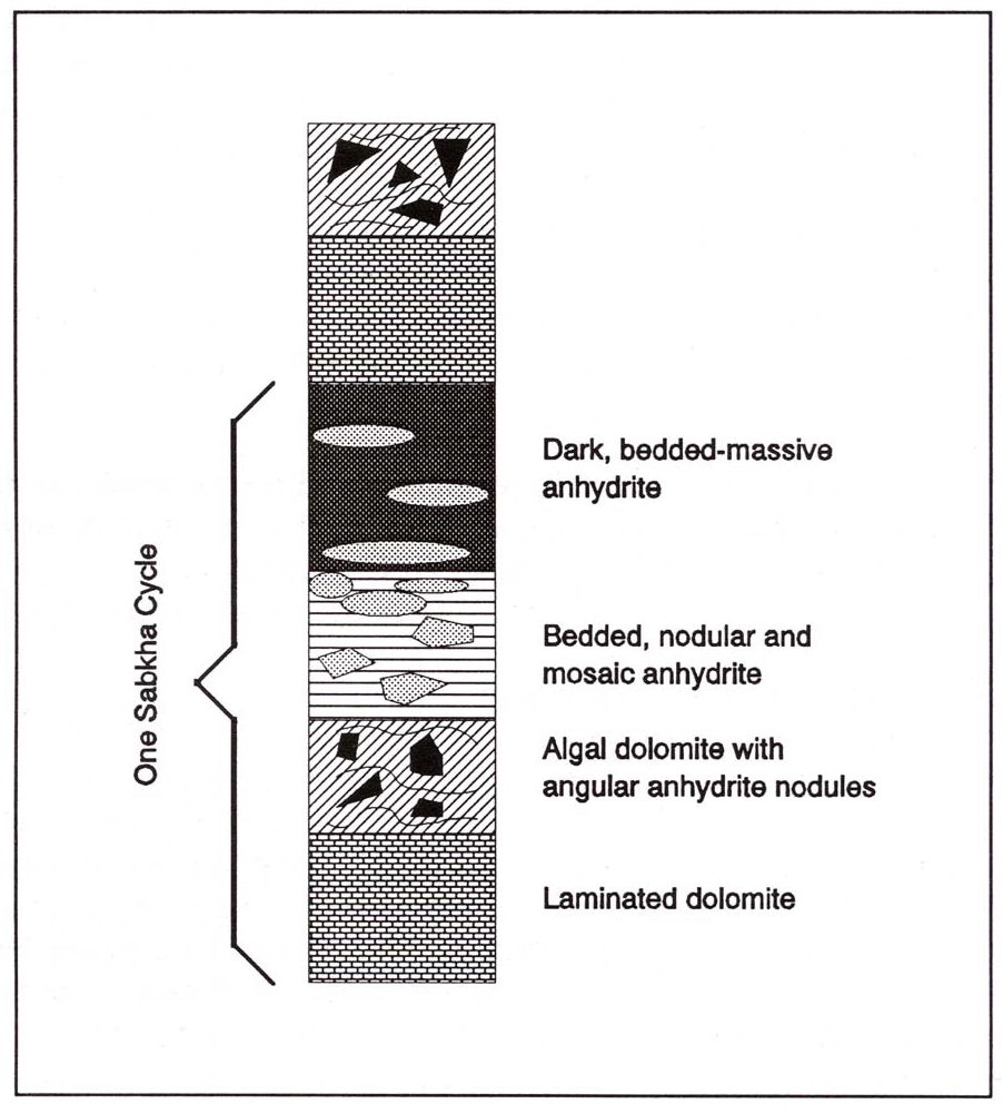 |
| Figure 9. Diagram of the layers of a sabkha cycle of the type found in the Rainbow area of Alberta, Canada, at depths of slightly more than 6,000 feet. Adapted from D. G. Bebout and W. R. Maiklem, "Ancient ahydrite facies and environments, Middle Devonian Elk Point basin, Alberta," Bulletin of Canadian Petroleum Geology, vol. 21, no. 3, 1973, Figures 3 and 24. |
Coastal sabkhas in the Persian Gulf (also called Arabian Gulf) region have been the object of intense study by petroleum geologists ever since the 1960's. A knowledge of these is valuable because of their similarity to some of the cyclic, sedimentary layers found in evaporite deposits which make up the impervious retaining cover over the petroleum reserves in many oil fields. A modern sabkha, such as is seen in the Trucial Coast of the Persian Gulf (Fig. 10), is a salt-encrusted flat, lying a short distance inland from the usual water's edge. It is at an elevation just above high tide, except that it is flooded over occasionally due to higher water resulting from storms. These inundations supply salt water which, when evaporated, adds to the sabkha's thickness. Also, there is some lateral seepage of salt water from the shore inland. In some places these "coastal sabkhas" are rather wide, extending inland as much as 8 or 10 miles. Also, there are older salt flats further inland with a width of as much as 60 miles. At one time they were nearer to the sea, but the production of carbonate sediments by the corals and other calcium-secreting marine organisms has now added some miles of width to the shore (progradation*). The present rate of this horizontal seaward movement of the shoreline is from one to two meters per year. The sabkhas which are presently next to the coast are thus believed to have been formed within the past 4,000 to 5,000 years (Kinsman, 1969, pp. 832, 839). At least one of these sabkhas is two cyclesin thickness (Butler, 1969, pp. 71-72).
So, a sabkha is made up of a specialized suite of sediments which are formed as a result of an arid-coast environment. Sabkhas are not found in other types of environment. In his section on "Supratidal* Evaporites," A. C. Kendall (1979) nicely summarizes some of the processes which come into play in forming a modern sabkha:
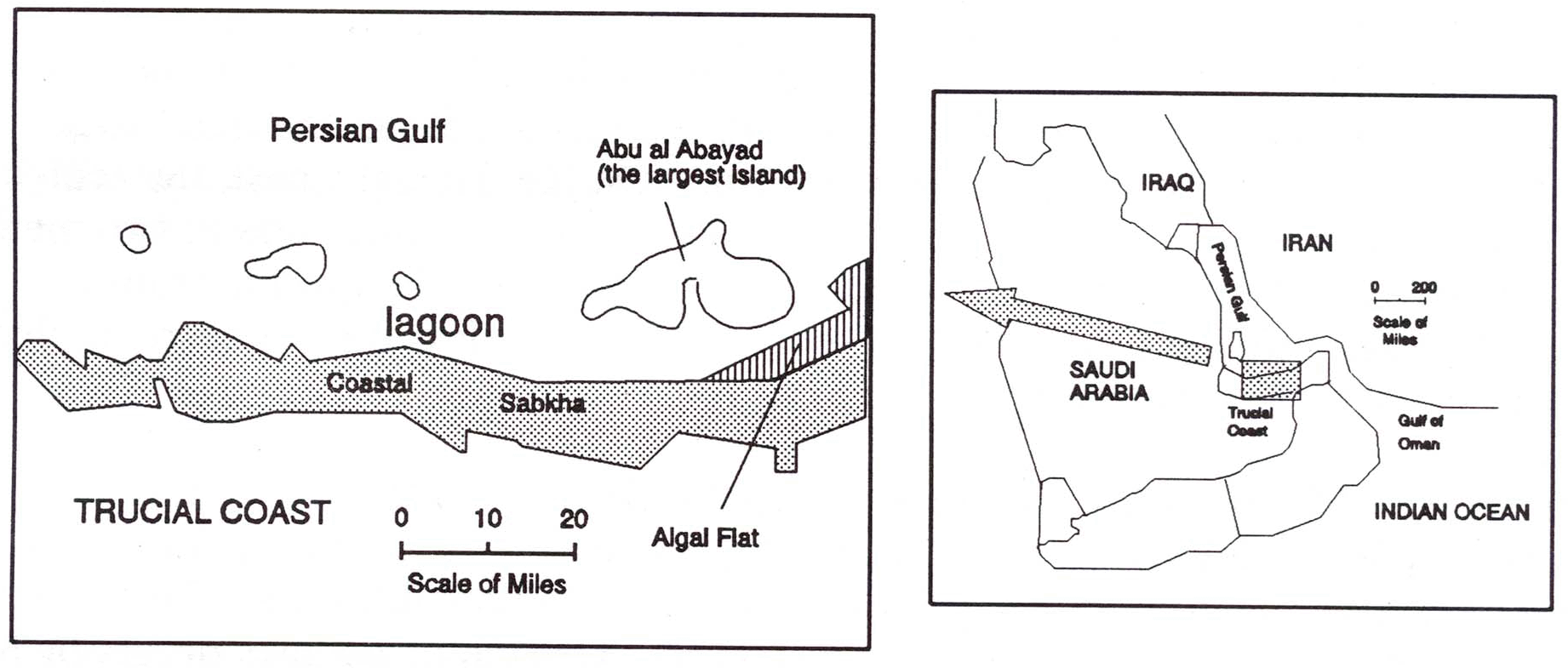 |
| Figure 10. Location and structure of the Trucial Coast, where extensive studies of modern evaporite formation and dolomitization have been made. In the larger figure, the coastal sabkha is a broad band along the coast, which lies just above the high-tide level. Redrawn from D. J. J. Kinsman, "Modes of formation, sedimentary associations, and diagnostic features of shallow-water and supratidal evaporites," American Association of Petroleum Geologists Bulletin, vol. 53, no. 4, 1969, Figure 2; and other sources. |
Because of the continuous loss of water and consequent concentration of the seawater minerals, precipitation and diagenetic processes occur within the accumulated sediments of the sabkha, resulting in the formation of alternating layers of gypsum (calcium sulfate) and dolomite. Algal mats which grow at the sediment surface of the more seaward parts of the sabkha play an important role in determining the final characteristics of the sabkha, as explained by C. G. Kendall and Skipwith (1969, pp. 844-52 and Fig. 16). In thinking about the large area of a sabkha as it extends back from the coast, one must realize that all of it was once at the water's edge, with an abundance of fine, filamentous strands of algae growing over the surface of the wet sand. These filaments of algae produce a protective slime for themselves that later becomes mixed with the finer beach sand which washes up over it as the tide comes in. Thus a thin, rather durable layer is produced, and a thickening series of successive layers (called a "laminated algal mat") is formed as the algal filaments continue to grow. Since these mats have a high percentage of carbonate sand, they are eventually converted to a layer of laminated dolomite or dolostone, if they are exposed to strong brines on the sabkha for a considerable period of time. The laminated dolostone layers, with the remnants of the algal mats, thus become a part of the permanent rock record as they are buried more deeply with time, and the beds of dolostone are spoken of as having "algal laminations." In the sabkha cycles of the Muskeg Formation in the Rainbow subbasin the algal-mat characteristics are prominent, as will be explained below.
We referred above to the alternating of gypsum layers with the dolomite layers in modern sabkhas. However, the gypsum is eventually converted to anhydrite, the more permanent form of calcium sulfate. (Practically all calcium sulfate in the older rock strata systems of the world is in the anhydrite form.) On the Trucial Coast, the sediments of the coast prograde out into the sea—usually at a rate of from one to two meters per year. This progradation eventually results in an isolation of the gypsum from the influence of the sea sufficient to allow it to be converted to anhydrite. Concerning this transformation, A. C. Kendall states:
In thinking about the deposition and development of sabkhas—whether modern or ancient—we need to keep in mind that the primary source of the minerals which are deposited is the seawater itself, and that these minerals are made available for deposition by the evaporation process in the coastal area. Thus the formation of any appreciable thickness in a sabkha cycle requires a considerable amount of time. The evaporation of seawater cannot produce a precipitation of more solid mineral amounts than are contained within the water. The thickness (depth) of water column which is evaporated on hot, arid coasts is usually between two and three meters per year (Dean, 1967, p. 144; Kushnir, 1981, p. 1194). The most rapid rate of evaporation known for anywhere in the world is approximately five meters per year (Kinsman, 1969, p. 830). If this is seawater of "normal" (average) mineral content, five meters could precipitate only about 1.8 mm of anhydrite (CaSO4). If the seawater were saturatedwith respect to CaSO4, then approximately 1.4 meters of water could precipitate 1.8 mm of anhydrite (Duff, 1967, p. 211). The only known way that the amount of calcium sulfate precipitation per year could be increased would be for some hydrothermal source to supply it in the local evaporite basin. However, no such supply to any of the modern areas of sabkha-cycle deposition on earth is known, and the ancient evaporite basins of Alberta which we have been discussing show no signs of appreciable influence from volcanic action or hydrothermal springs. If there had been such, there would be recognizable indications of it, as in the Yellowstone National Park, where recognizable hydrothermal mineral deposits are formed. However, the Yellowstone deposits have almost no resemblance to those of either the modern or the ancient evaporite deposits we have cited.
Also, we have to discount the possibility of any sizable amount of minerals being contributed to these deposits by hydrothermal circulation of seawater from submarine rift systems of the oceans. The rift openings are in the deep ocean floor, far from the shallow, epicontinental seas where the evaporites of Alberta were being deposited. The only effect the submarine rift systems can have on shallow-water deposition of evaporites is to contribute to the total mineral content of the seawater which eventually arrives at the coastal areas.
If one should wish for even further evidence that ancient stratified evaporites which are found on the continents were formed in coastal areas and inland seas by slow, natural evaporation, he should consider the following. There is an abundance of pollen grains and other spores from the higher phyla of plants, uniformly distributed over wide areas in many of the evaporite layers of the world. These pollen grains and spores are found at many stratigraphic levels in the evaporite formations. (Kiaus, 1969, pp. 30-32). This fact, together with the usual uniform distribution over a wide area, shows that the pollen and spores could not have been deposited by the Flood, or by subterranean hydrothermal springs—because each of the many depositional levels was being supplied from living forests (most likely by at least relatively dry winds, carrying the pollen and spores out over the evaporative seas). Klaus points out that in most evaporite deposits the pollen and spores are very well preserved and readily identifiable, because of the preserving effect of the salt (1969, pp. 30-31). It is significant also that, in most evaporative basin deposits, the "salt clays" which lie closer to the edge of the basin than the concentrated salts which formed near the center, possess from a few to many times the spore concentration found in the salts near the center. This is to be expected because the edges of the basin were closer to the forests where the spores were being produced. (Klaus, 1969, p. 32)
In the study of the cycles in the Rainbow area, Bebout found that each cycle usually has a thickness of from two to four feet. Those cycles which are complete are made up of four zones or layers which are similar to the zones of the modern Trucial Coast deposits. (See Figure 9 for a drawing of these, accompanied by a description of the contents of each zone.) In the text, Bebout and Maiklem (1973, p. 322) explain:
Immediately above the series of 20 sabkha cycles are 15 more cycles which are similar, but less complex. These are made up of two main components: nodular anhydrite layers alternating with dolostone. Their total thickness is somewhat more than 100 feet. It should be noted that nodular anhydrite such as this (with large nodules) is a very reliable indication of coastal deposition. These nodules form at or very near the surface of the salt flat which is exposed to the wind and sun.
As for the length of time involved in the forming of these 35 vertically sequential cycles in Alberta, we should note the total of their thicknesses (about 250 feet) and compare this to the small amounts which can be deposited in one year, discussed above. Also we should consider the length of time required for each cycle, as seen in the Persian Gulf area. The very nature of the sedimentary components of the cycle demands a period of at least a few thousand years for forming such a salt flat of even six miles width. According to the studies made by D. J. Kinsman on the Trucial Coast of Arabia, to which we referred earlier, the present rate of shoreline progradation (increase of land) would broaden the sabkhas approximately one mile each 1,000 years. He estimates that the flats which are six miles wide have required about 5,000 years for their formation. (Kinsman, 1969, pp. 832, 839.) These six-mile expanses of organized salt flat are only one or two sabkha cycles thick. So, even if the 35 sequential cycles of northern Alberta could have developed without any interruptions, this indicates that a minimum of 87,500 years (35/2 x 5,000) were required for their accumulation. (Because of several depositional limiting factors, this figure is unrealistically small.) Note also that this relatively brief time span is in addition to all the time for development of the Lower Muskeg Formation, the extensive carbonate buildups, and the earlier evaporitic deposits below the reefs. And this is all in addition to the vast amount of time required for adding the nearly 6,000 feet of other types of sedimentary rock which lie above the Muskeg Formation. (For a discussion of the latter, see Wonderly, 1977, pp. 83-84, 90-91, and the references cited there.)
It may be that some young-earth creationists will object to the above estimates of depositional time periods, saying that they are too dependent upon uniformitarian principles. Such persons frequently hypothesize that in former times climatic conditions were entirely different from what they are now, and that this made it possible for practically all types of sedimentary deposition to occur at rates many times faster than those we see today. This is false reasoning which leads only to erroneous conclusions.
Remember that we are here dealing with arid-climatedeposition, as is abundantly obvious from the sabkha-cycle sediments in the Rainbow and other subbasins of Alberta. We must also realize that we are considering the past history of an earth which remained at least reasonably hospitableto animal and plant life after these were created. Exceptions to this were the year of the Biblical Flood and perhaps a few earlier periods when asteroid impacts produced temporary changes in the climate. Neither of these exceptions was anything which would produce sabkha-cycles or evaporite strata. If we keep in mind that we are dealing with an earth which remained reasonably hospitable to plant and animal life, we cannotpostulate that the arid climate necessary for producing sabkha cycles and several other types of evaporite deposits was intensified to where the deposition occurred in a mere thousand years instead of 87,500 or more. Hot sun and high evaporation rates such as exist in the Persian Gulf region are fundamental elements in the production of such deposits. Try intensifying those conditions by a factor of 87, or even 8.7, and you will have an earth without plant and animal life on it. So, glibly assuming an intensification of ancient environments for the purpose of "speeding up" depositional rates in prehistoric times is an irresponsible and futile exercise. We should never blindlyapply uniformitarian principles; but, on the other hand, we must avoid making assumptions which will lead the scientific community to conclude that we are blindto the survival requirements of plant and animal life.
In a consideration of the evaporite deposits of the oil fields of Alberta it is important for creationists to note the fact that the layers and cycles are nearly always characterized by a lateral uniformity and sedimentary content which is typical of normal evaporite deposition. There is no logical way to postulate that these strata were deposited by the Biblical Flood, for several reasons. We have already discussed some of these reasons; two others which we should at least mention are: (1) Since anhydrite and halite are readily soluble in water, floods dissolverather than deposit them. (2) In practically all of the layers of the Muskeg Formation, over the broad areas covered by it, coarse terrigenous* components such as quartz sand and gravel are rare, if present at all (Klingspor, 1969). In a convulsive flood such as the Bible describes, great amounts of these non-marine components would have been mixed into any covering layers which were deposited over the reefs of the basins. (Of course there are many such terrigenous components in some of the thick formations which lie above the Muskeg Formation, but these were unrelated to—and later than—the evaporite era.)
Whitcomb and Morris, in their early work (1961) mentioned stratified evaporite beds, and said that they were likely formed by non-evaporative processes. In their words, "Modern writers are gradually coming to the opinion that even the stratified evaporite beds are very largely the result of metamorphic processe…." (pp. 416-17). But this statement is completely inapplicable to the evaporite beds we have been discussing. Neither of the geologists they quote (from the 1950's) was referring to evaporites of the types which are so widespread in the oil fields of Alberta and many other parts of the world. In fact, most of the evaporite deposits which have been described to date were either unknown or completely undescribed in 1961 when the Whitcomb and Morris book was published. However, during the 1960's an astonishing number of research projects on evaporites were carried out, with the publication of great amounts of data. These provided clarifications concerning the environmental relationships between the deposi tion of the many carbonate petroleum reservoirs which were biogenically produced and the periods of desiccation which interrupted their growth and laid down evaporite layers over them.
Unfortunately, the writings of Whitcomb and Morris, even to the present time, show no indication that they have studied any of these research reports. Except for Morris's statements on halite deposits in the ocean floors, their treatments of the subject of evaporites are wholly unreliable, and are not based on any appreciable amount of scientific data. Thus the young-earth creationist community has not only failed to understand most of the evaporite deposits but has missed out on one of the strongest positive evidences for great age that we have in the earth's sedimentary cover.
5. Cyclic Evaporites and Reefs in the Michigan Basin
Another well-known geographic area of cyclic deposition such as we have described in Canada is found in the southern and central part of Michigan. Here, in what is called the Michigan Basin, many forms of carbonate mounds, including a great number of relatively small, conical reefs, are covered with repeating beds of evaporites. This area was a large inland sea during much of the Paleozoic Era, and then later somewhat uplifted. The conical reefs which developed in the basin are called "pinnacle reefs," though their sides are not as steep as the name would imply. They contain abundant, identifiable, frame-building corals, and their positions, sedimentary and fossil make-up, and other characteristics give indisputable evidence that they grew in situ,just inside the north rim and south rim of the basin. Their carbonate components and the progression of the fossil components from the lower-to-upper levels shows that their growth was in stages, interrupted by long periods of low sea level with evaporative conditions. Thick layers of anhydrite and halite thus lap up onto the sides of these reefs, and intertongue with the reef layers which developed later. Many of the reefs have vertically sequential zones which are dominated by crinoids, corals and algae, and stromatoporoids, respectively (Mesolella, et al., 1974, pp. 34, 43, 45, and 52). Also of great significance is the presence of stromatolites* which grew on the surface of some of these reefs at times when there was a low water level and the proper environmental conditions for growh of the algal mats which form stromatolites (Mesolella, et al, 1974, p. 45).
Because these Michigan Basin reefs have a high porosity and are sealed over by evaporite layers, they are significant oil producers, and therefore have been the subject of detailed studies by geologists for the past three decades. They lie at a depth of approximately one mile, subsurface, and have been extensively cored in many of the drillings. There is thus an abundance of high quality reef and evaporite materials for study of the cyclic sequences. One of the best papers describing these is the one cited in the paragraph just above (Mesolella, et al., 1974). Other very helpful sources are Jodry (1969), Gill (1977), and Reading, et al. (1986, pp. 218, 225-26). As was mentioned in the Mesolella paper, p. 35, there is some controversy among geologists concerning details of the order and causes of deposition, but there is abundant agreement on the fact that the evaporites and reefs were deposited naturally, by stages, in response to definite changes in the environment in the Basin. (To disagree on that would be a brazen rejection of immense amounts of easily-understood core samples and other data.) Many of the reasons for the earlier controversy over the type of evaporite deposition which prevailed in this basin have now been clarified. As Reading, et al. (1986, pp. 225-26) explain, research during the past decade has revealed many unmistakable evidences for the "desiccated-basin model" as applying to at least most of the evaporite deposition of the carbonate-reef-and-shelf area.
Creationists who have asked about the possibility of the evaporite coverings of the reefs being the result of volcanic or hydrothermal activity will find, upon studying the Michigan Basin, there is no possibility of this. Igneous* activity occurred in the Late Precambrian times, but there is no sign of such in the Paleozoicsystems of that area—in spite of very extensive drilling explorations and commercial production for many years in the Michigan Basin (W. B. Harrison III, a professor in the Dept. of Geology of Western Michigan University, Kalamazoo; personal communication, 1986). There are a few thin layers of ash-containing sediment—sometimes called bentonite—in the Devonian, Silurian, and possibly Ordovician Systems in the Michigan Basin, but these are evidently from atmosphere-transported ash derived from volcanoes which were in the eastern part of the Appalachians. (The bentonite layers become more evident farther east as one traces them across Ohio, West Virginia, and Virginia, to the source area.) No evidence for either intrusive or extrusive igneous processes is found in the Paleozoic systems of the Michigan Basin. (W. B. Harrison III, personal communication, 1986.)
So, the Michigan Basin cyclic evaporites and reefs effectively provide us with another overwhelmingly clear body of evidence for the deposition of thick formations of carbonate and evaporite rock layers by organic growth alternating with marine evapora tion. There is really no way that we could honestly reject the implications of the immense body of data which he have from both the Canadian and Michigan petroleum explorations.
1See Alonso (1991) concerning the great contrasts between evaporite deposits such as these, and evaporites formed by waters of hydrothermal origin. Both normal-marine and continental evaporites are very different from the latter.
2One difference between these basal, laminated parts of the Muskeg Formation and the laminated Castile Formation is that, in the couplets of the Muskeg, the carbonate laminae are more often composed of dolomite rather tha calcite, as in the Castile Formation. This is not a major difference, however, as calcite (CaCO3) deposits are sometimes altered to dolomite (CaMg(C03)2) either soon after deposition or considerably later. Whether this diagenetic chage will be early or late depends upon a number of environmental factors, including, importantly, the availability of the necessary magnesium ions from circulating pore water.
3See Chapter 3 for an explanation of some principles of this type of rock cementation.
4For a table of the sedimentary
rock units which lie above the reefs of the Rainbow subbasin in
northern
Alberta, and a discussion of the sediment types, see Wonderly (1977),
pp.
83-84.